
On this date 65 years ago, February 1st 1953, the Netherlands experienced its greatest flood till date, the North Sea Flood of 1953. This is still one of the biggest disasters the Netherlands has ever experienced, with thousands of casualties and lots of people who lost their homes.
The Netherlands earns its name from the fact that large parts of the country lie below sea level. To make sure our country doesn’t flood, we have built lots of barriers, dams and dykes to keep the water out, and we want to prevent anything like the flood of 1953 from happening ever again.
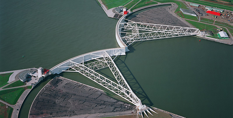
In the beginning of this year, several of these barriers and dams were put to the test when a heavy storm reached the Netherlands which resulted in very high water levels. Our five biggest dams and barriers needed to be closed at the same time, a first since their construction. We can ask ourselves the question whether this will happen more often now that sea levels are rising due to global warming 1. A higher base line sea level increases the chance for even higher water levels when it storms. To get an idea what areas would be affected the most by a possible flood, we have created a visualisation project that shows the height of the Netherlands in comparison to the sea level.
Things to check out
- The Y-axis shows deviation from “Amsterdam Ordnance Datum“
- You can zoom on both the map and the elevation profile (by selecting a region in the bottom profile).
- If you hover your mouse over the elevation profile, a red dot will show you the location on the map
- The highest point in our country is the Vaalserberg, with a whopping 322 m! It’s in the most southern part of the Netherlands. Some people, however, may claim it’s not really part of the Netherlands because of their ugly accents ;)
- If you zoom in on our shorelines, you can see our dykes
Elevation profiles of the Netherlands
Technical details
Quick links
- Data source: http://ahn.nl
- We use AHN version 2 and the dataset with a resolution of 5 meter
- Written in Python and CoffeeScript, and available on Github: https://github.com/lrvdijk/nl-height
Algorithm overview
- The publicly available height data is split across multiple “raster data” files. The AHN website provides a “ahn_units.shp” shapefile, that shows which part of the Netherlands is covered by which raster data file, and thus shows which file to download.
- We import this ahn_units shapefile in a PostgreSQL database with the PostGIS extension enabled. A script downloads and extracts all available raster data files.
- When all data is downloaded, we import the raster data in our PostgreSQL database.
- To generate an elevation profile, we draw a line horizontally across the Netherlands and query which cells in our raster data hit our line. Each cell contains the height at its midpoint. Our query is based on this blogpost: http://blog.mathieu-leplatre.info/drape-lines-on-a-dem-with-postgis.html
- When there’s water, no data exists in our database. We apply some post-processing such that our visualisation does not get weird artefacts.
- We store the data in a JSON file, and use the d3.js library for the visualisation.